
Accueil / OHM Vallée du Rhône / Archives cartographiques et topographiques /
Map/Cross section (Aramon to Vallabrègues, 1863-1864)
44/350
)
)
)
)
)
)
)
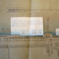
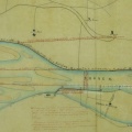
: Rectification et défense de la rive droite du bras d'Aramon entre la Roubine des Agaces et le barrage du Bosquet sur 600 m de longueur. English title: Rectification and defence of the right bank of the Aramon channel between the Roubine des Agaces and the Bosquet dam over a length of 600 m.")
Original title (in French): Rectification et défense de la rive droite du bras d'Aramon entre la Roubine des Agaces et le barrage du Bosquet sur 600 m de longueur. English title: Rectification and defence of the right bank of the Aramon channel between the Roubine des Agaces and the Bosquet dam over a length of 600 m.
- Auteur
- Kleitz
- Tags
- Fonds/Photographic fund
- Archives Nationales (France), Archives Départementales du Rhône (reference: F/14/6584, S 1439)
- Contributeurs/Contributors
- Nature de la ressource/Resource type
- Map/Cross section
- Date
- Période/Period
- 1863-1864
- Commune/Municipality
- Secteur/Sector
- Aramon to Vallabrègues (7,5 km long)
- Echelle/Scale
- 1/10 000
- Lieu visé ou point de visée/Targeted place or photographer geolocation
- Projet OHM/OHM project
- Complément d'information/Additional information
- 3 maps, 2 cross sections
- Ressource liée/Linked resource
- DOI
- Copyright
- Creative Commons (BY-NC)