
Accueil / OHM Vallée du Rhône / Archives cartographiques et topographiques /
Map/Cross section (Lyon, 1854)
43/350
)
)
)
)
)
)
)
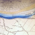
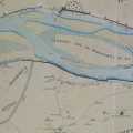
: Plan de la rive droite en amont du pont de la Guillotière, avec l'indication des usines et bateaux à laver, en station sur le fleuve. English title: Map of the right bank upstream of the Guillotière bridge, with indication of the factories and wash-house boats in station on the river.")
Original title (in French): Plan de la rive droite en amont du pont de la Guillotière, avec l'indication des usines et bateaux à laver, en station sur le fleuve. English title: Map of the right bank upstream of the Guillotière bridge, with indication of the factories and wash-house boats in station on the river.
- Auteur
- Thiollière
- Tags
- Fonds/Photographic fund
- Archives Nationales (France) (reference: F/14/6708)
- Contributeurs/Contributors
- Nature de la ressource/Resource type
- Map/Cross section
- Date
- Période/Period
- 1854
- Commune/Municipality
- Secteur/Sector
- Lyon (3,5 km long)
- Echelle/Scale
- 1/1000
- Lieu visé ou point de visée/Targeted place or photographer geolocation
- Projet OHM/OHM project
- Complément d'information/Additional information
- 17 cross sections of the right side of the channel
- Ressource liée/Linked resource
- DOI
- Copyright
- Creative Commons (BY-NC)