
Início / OHM Vallée du Rhône / Archives cartographiques et topographiques /
Map/Bathymetry (Lyon to the sea, 1874-1876)
277/350
)
)
)
)
)
)
)
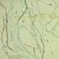
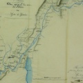
: Avant-projet général pour l'amélioration du Rhône. English title: General preliminary project for the improvement of the Rhône river.")
Original title (in French): Avant-projet général pour l'amélioration du Rhône. English title: General preliminary project for the improvement of the Rhône river.
- Autor
- Tavernier et al.
- Tags
- Fonds/Photographic fund
- Archives Nationales (France) (reference: F/14/6808)
- Contributeurs/Contributors
- Nature de la ressource/Resource type
- Map/Bathymetry
- Date
- Période/Period
- 1874-1876
- Commune/Municipality
- Secteur/Sector
- Lyon to the sea (329 km long)
- Echelle/Scale
- 1/10 000
- Lieu visé ou point de visée/Targeted place or photographer geolocation
- Projet OHM/OHM project
- Complément d'information/Additional information
- 11 sheets. Not entirely photographed
- Ressource liée/Linked resource
- DOI
- Copyright
- Creative Commons (BY-NC)
- Make
- Canon
- Model
- Canon PowerShot G9
- DateTimeOriginal
- 2017:12:08 16:17:52
- ApertureFNumber
- f/2.8