
71/350
)
)
)
)
)
)
)
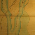
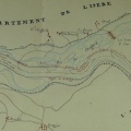
: Cartes des embouchures du Rhône. English title: Map of the Rhône mouths.")
Original title (in French): Cartes des embouchures du Rhône. English title: Map of the Rhône mouths.
- Author
- Danville et al.
- Tags
- Fonds/Photographic fund
- Archives Nationales (France) (reference: F/14/6807)
- Contributeurs/Contributors
- Nature de la ressource/Resource type
- Map/Text
- Date
- Période/Period
- 1706-1846
- Commune/Municipality
- Secteur/Sector
- Arles to the sea (53 km long)
- Echelle/Scale
- Toises, 1/20 000, 1/160 000
- Lieu visé ou point de visée/Targeted place or photographer geolocation
- Projet OHM/OHM project
- Complément d'information/Additional information
- 5 texts (front page photographed) and 5 maps
- Ressource liée/Linked resource
- DOI
- Copyright
- Creative Commons (BY-NC)
- Make
- Canon
- Model
- Canon PowerShot G9
- DateTimeOriginal
- 2017:12:08 15:31:06
- ApertureFNumber
- f/2.8