
300/350
)
)
)
)
)
)
)
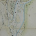
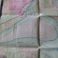
: Carte générale du canal de Beaucaire (...). English title: General map of the Beaucaire canal (...).")
Original title (in French): Carte générale du canal de Beaucaire (...). English title: General map of the Beaucaire canal (...).
- Author
- NA
- Tags
- Fonds/Photographic fund
- Archives Nationales (France) (reference: CP/F/14/10087/"Canal de Beaucaire". File 4-Piece 2)
- Contributeurs/Contributors
- Nature de la ressource/Resource type
- Map
- Date
- Période/Period
- 1823
- Commune/Municipality
- Secteur/Sector
- Beaucaire to the sea (65 km long)
- Echelle/Scale
- ~ 1/100 000
- Lieu visé ou point de visée/Targeted place or photographer geolocation
- Projet OHM/OHM project
- Complément d'information/Additional information
- Not entirely photographed
- Ressource liée/Linked resource
- DOI
- Copyright
- Creative Commons (BY-NC)