
Início / OHM Vallée du Rhône / Archives cartographiques et topographiques /
Map (Durance confluence to the sea, 1841)
46/350
)
)
)
)
)
)
)
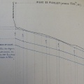
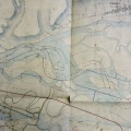
: Plan général du cours du Rhône embrassant les emplacements des digues à reconstruire dans le département des Bouches du Rhône. English title: General map of the Rhône river encompassing the locations of the dykes to be rebuilt in the Bouches-du-Rhône department .")
Original title (in French): Plan général du cours du Rhône embrassant les emplacements des digues à reconstruire dans le département des Bouches du Rhône. English title: General map of the Rhône river encompassing the locations of the dykes to be rebuilt in the Bouches-du-Rhône department .
- Autor
- Ponts & Chaussées
- Tags
- Fonds/Photographic fund
- Archives Nationales (France), Archives Départementales du Rhône (reference: F/14/6537, S 1454)
- Contributeurs/Contributors
- Nature de la ressource/Resource type
- Map
- Date
- Période/Period
- 1841
- Commune/Municipality
- Secteur/Sector
- Durance confluence to the sea (82 km long)
- Echelle/Scale
- 1/25 000
- Lieu visé ou point de visée/Targeted place or photographer geolocation
- Projet OHM/OHM project
- Complément d'information/Additional information
- 2 maps with different titles but similar survey in April and December 1841
- Ressource liée/Linked resource
- DOI
- Copyright
- Creative Commons (BY-NC)