
328/350
)
)
)
)
)
)
)
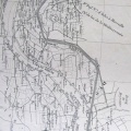
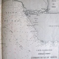
: Carte du cours du Rhône du Pont de Donzère à la mer. English title: Map of the Rhône river from the Donzère bridge to the sea.")
Original title (in French): Carte du cours du Rhône du Pont de Donzère à la mer. English title: Map of the Rhône river from the Donzère bridge to the sea.
- Author
- Ponts & Chaussées
- Tags
- Fonds/Photographic fund
- Bibliothèque Nationale de France (reference: Ge-DD.5537)
- Contributeurs/Contributors
- Nature de la ressource/Resource type
- Map
- Date
- Période/Period
- 1876
- Commune/Municipality
- Secteur/Sector
- Donzère to Aramon (84 km long)
- Echelle/Scale
- 1/40 000
- Lieu visé ou point de visée/Targeted place or photographer geolocation
- Projet OHM/OHM project
- Complément d'information/Additional information
- Sheets 10 to 14. Sheet 15 missing
- Ressource liée/Linked resource
- DOI
- Copyright
- Creative Commons (BY-NC)
- Make
- Canon
- Model
- Canon PowerShot G9
- DateTimeOriginal
- 2017:04:18 07:31:06
- ApertureFNumber
- f/2.8