
Accueil / OHM Vallée du Rhône / Archives cartographiques et topographiques /
Map (St Rambert to Pont-St-Esprit, 1833)
9/350
)
)
)
)
)
)
)
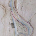
: Plan de la partie du cours du Rhône et de la rive gauche de ce fleuve comprise dans le département de la Drôme, entre l'embouchure du ruisseau du Dolon (...) et celle du Lauzon. English title: Plan of the part of the Rhône river and the left bank of this river included in the department of the Drôme, between the Dolon confluence (...) and that of the Lauzon.")
Original title (in French): Plan de la partie du cours du Rhône et de la rive gauche de ce fleuve comprise dans le département de la Drôme, entre l'embouchure du ruisseau du Dolon (...) et celle du Lauzon. English title: Plan of the part of the Rhône river and the left bank of this river included in the department of the Drôme, between the Dolon confluence (...) and that of the Lauzon.

- Auteur
- Grailly
- Tags
- Fonds/Photographic fund
- Archives Nationales (France) (reference: CP/F/14/10074/1/B/piece34)
- Contributeurs/Contributors
- Nature de la ressource/Resource type
- Map
- Date
- Période/Period
- 1833
- Commune/Municipality
- Secteur/Sector
- St Rambert to Pont-St-Esprit (130 km long)
- Echelle/Scale
- 1/10 000
- Lieu visé ou point de visée/Targeted place or photographer geolocation
- Projet OHM/OHM project
- Complément d'information/Additional information
- Map of 12 m long. Name of some islands but not their nature. Left bank only. The Drôme River is visible
- Ressource liée/Linked resource
- DOI
- Copyright
- Creative Commons (BY-NC)