
Accueil / OHM Vallée du Rhône / Archives cartographiques et topographiques /
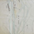
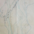
Map (Bourg-St-Andéol to the sea, 1781)
259/350
)
)
)
)
)
)
)
: Plan du cours du Rhône. English title: Map of the Rhône river.")
Original title (in French): Plan du cours du Rhône. English title: Map of the Rhône river.
- Auteur
- Grandvoinet
- Tags
- Fonds/Photographic fund
- Archives Départementales du Gard (reference: C.161 )
- Contributeurs/Contributors
- Nature de la ressource/Resource type
- Map
- Date
- Période/Period
- 1781
- Commune/Municipality
- Secteur/Sector
- Bourg-St-Andéol to the sea (154 km long)
- Echelle/Scale
- 1/3600
- Lieu visé ou point de visée/Targeted place or photographer geolocation
- Projet OHM/OHM project
- Complément d'information/Additional information
- Sheets 21 to 55
- Ressource liée/Linked resource
- DOI
- Copyright
- Creative Commons (BY-NC)
- Make
- Canon
- Model
- Canon EOS 5D Mark II
- DateTimeOriginal
- 2014:01:14 15:30:57
- ApertureFNumber
- f/4.0