
Accueil / OHM Vallée du Rhône / Archives cartographiques et topographiques /
Map (Yenne to Cordon, 18th c.)
77/350
)
)
)
)
)
)
)
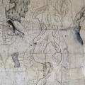
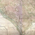
: Plan d'une partie du cours du Rhône depuis Cordon jusqu'à Hyenne pour servir à déterminer l'emplacement d'un bac à traille pour la communication de Provence en Bugey. English title: Map of part of the Rhône river from Cordon to Hyenne to be used to determine the location of a cable ferry for communication between Provence and Bugey.")
Original title (in French): Plan d'une partie du cours du Rhône depuis Cordon jusqu'à Hyenne pour servir à déterminer l'emplacement d'un bac à traille pour la communication de Provence en Bugey. English title: Map of part of the Rhône river from Cordon to Hyenne to be used to determine the location of a cable ferry for communication between Provence and Bugey.
- Auteur
- NA
- Tags
- Fonds/Photographic fund
- Archives Nationales (France) (reference: CP/F/14/10074/1/A/piece3)
- Contributeurs/Contributors
- Nature de la ressource/Resource type
- Map
- Date
- Période/Period
- 18th c.
- Commune/Municipality
- Secteur/Sector
- Yenne to Cordon (24 km long)
- Echelle/Scale
- 1/30 000
- Lieu visé ou point de visée/Targeted place or photographer geolocation
- Projet OHM/OHM project
- Complément d'information/Additional information
- Ressource liée/Linked resource
- DOI
- Copyright
- Creative Commons (BY-NC)