
62/350
)
)
)
)
)
)
)
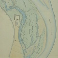
: Prolongement de la digue de Chateauneuf. English title: Extension of the Chateauneuf dyke.")
Original title (in French): Prolongement de la digue de Chateauneuf. English title: Extension of the Chateauneuf dyke.
- Autor
- Kleitz
- Tags
- Fonds/Photographic fund
- Archives Nationales (France), Archives Départementales du Rhône (reference: F/14/6566, 3959 W 1680)
- Contributeurs/Contributors
- Nature de la ressource/Resource type
- Map
- Date
- Période/Period
- 1859
- Commune/Municipality
- Secteur/Sector
- Viviers (5 km long)
- Echelle/Scale
- 1/10 000
- Lieu visé ou point de visée/Targeted place or photographer geolocation
- Projet OHM/OHM project
- Complément d'information/Additional information
- Ressource liée/Linked resource
- DOI
- Copyright
- Creative Commons (BY-NC)
- Make
- Canon
- Model
- Canon PowerShot G9
- DateTimeOriginal
- 2017:12:08 16:34:18
- ApertureFNumber
- f/4.0