
Home / OHM Vallée du Rhône / Archives cartographiques et topographiques /
Map/Cross section (Pont-St-Esprit, 1856)
70/350
)
)
)
)
)
)
)
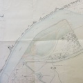
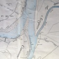
: Délimitation du Rhône en amont du Pont-St-Esprit. English title: Demarcation of the Rhône river upstream of Pont-St-Esprit.")
Original title (in French): Délimitation du Rhône en amont du Pont-St-Esprit. English title: Demarcation of the Rhône river upstream of Pont-St-Esprit.
- Author
- Kleitz
- Tags
- Fonds/Photographic fund
- Archives Nationales (France) (reference: F/14/6779)
- Contributeurs/Contributors
- Nature de la ressource/Resource type
- Map/Cross section
- Date
- Période/Period
- 1856
- Commune/Municipality
- Secteur/Sector
- Pont-St-Esprit (2 km long)
- Echelle/Scale
- ~ 1/2500
- Lieu visé ou point de visée/Targeted place or photographer geolocation
- Projet OHM/OHM project
- Complément d'information/Additional information
- Cross sections surveyed in 1850 & 1855
- Ressource liée/Linked resource
- DOI
- Copyright
- Creative Commons (BY-NC)
- Make
- Canon
- Model
- Canon PowerShot G9
- DateTimeOriginal
- 2018:04:10 06:43:19
- ApertureFNumber
- f/4.0