
258/350
)
)
)
)
)
)
)
: Plan de l'Isle d'Oiselet, relatif à la demande d'une subvention de la part de l'Etat formée par M.Bruguier, pour la réparation des avaries causées par l'inondation de 1840, aux levées de ses domaines de la Bonète et de la Perrine. English title: Plan of Isle d'Oiselet, related to the request for a subsidy from the State formed by Mr. Bruguier, for the repair of the damages caused by the flood of 1840, to the levees of its domains of Bonète and Perrine.")
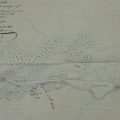
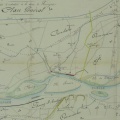
Original title (in French): Plan de l'Isle d'Oiselet, relatif à la demande d'une subvention de la part de l'Etat formée par M.Bruguier, pour la réparation des avaries causées par l'inondation de 1840, aux levées de ses domaines de la Bonète et de la Perrine. English title: Plan of Isle d'Oiselet, related to the request for a subsidy from the State formed by Mr. Bruguier, for the repair of the damages caused by the flood of 1840, to the levees of its domains of Bonète and Perrine.
- Autor
- Bouvier
- Tags
- Fonds/Photographic fund
- Archives Nationales (France) (reference: F/14/6777)
- Contributeurs/Contributors
- Nature de la ressource/Resource type
- Map
- Date
- Période/Period
- 1841
- Commune/Municipality
- Secteur/Sector
- Sorgues (7 km long)
- Echelle/Scale
- 1/10 000
- Lieu visé ou point de visée/Targeted place or photographer geolocation
- Projet OHM/OHM project
- Complément d'information/Additional information
- Ressource liée/Linked resource
- DOI
- Copyright
- Creative Commons (BY-NC)
- Make
- Canon
- Model
- Canon PowerShot G9
- DateTimeOriginal
- 2018:04:10 04:48:02
- ApertureFNumber
- f/4.0