
233/350
)
)
)
)
)
)
)
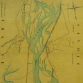
: Plan de l'ile et des digues de la Barthelasse dressé par l'ingénieur ordinaire soussigné pour être joint à son rapport en date de ce jour sur les augmentations de dépense occasionnées par la réparation des dites digues. English title: Plan of the Barthelasse island and dykes surveyed by the undersigned ordinary engineer to be attached to his todays report on the increases in expenditure caused by the repair of the said dykes.")
Original title (in French): Plan de l'ile et des digues de la Barthelasse dressé par l'ingénieur ordinaire soussigné pour être joint à son rapport en date de ce jour sur les augmentations de dépense occasionnées par la réparation des dites digues. English title: Plan of the Barthelasse island and dykes surveyed by the undersigned ordinary engineer to be attached to his todays report on the increases in expenditure caused by the repair of the said dykes.
- Author
- Perrier
- Tags
- Fonds/Photographic fund
- Archives Nationales (France) (reference: F/14/6583)
- Contributeurs/Contributors
- Nature de la ressource/Resource type
- Map
- Date
- Période/Period
- 1841
- Commune/Municipality
- Secteur/Sector
- Roquemaure (10 km long)
- Echelle/Scale
- 1/10 000
- Lieu visé ou point de visée/Targeted place or photographer geolocation
- Projet OHM/OHM project
- Complément d'information/Additional information
- Ressource liée/Linked resource
- DOI
- Copyright
- Creative Commons (BY-NC)
- Make
- Canon
- Model
- Canon PowerShot G9
- DateTimeOriginal
- 2018:04:11 04:50:03
- ApertureFNumber
- f/4.0