
Accueil / OHM Vallée du Rhône / Archives cartographiques et topographiques /
Map (Beaucaire, 1838-1840)
232/350
)
)
)
)
)
)
)
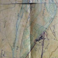
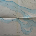
: Plan du cours du Rhône aux abords du Mas de Ranchier pour être joint aux profils et métré du barrage. English title: Map of the Rhône river near the Mas de Ranchier, to be attached to the profiles and metering of the dam.")
Original title (in French): Plan du cours du Rhône aux abords du Mas de Ranchier pour être joint aux profils et métré du barrage. English title: Map of the Rhône river near the Mas de Ranchier, to be attached to the profiles and metering of the dam.
- Auteur
- Ponts & Chaussées
- Tags
- Fonds/Photographic fund
- Archives Départementales du Rhône (reference: S 1448)
- Contributeurs/Contributors
- Nature de la ressource/Resource type
- Map
- Date
- Période/Period
- 1838-1840
- Commune/Municipality
- Secteur/Sector
- Beaucaire (1 km long)
- Echelle/Scale
- 1/5000
- Lieu visé ou point de visée/Targeted place or photographer geolocation
- Projet OHM/OHM project
- Complément d'information/Additional information
- 2 maps
- Ressource liée/Linked resource
- DOI
- Copyright
- Creative Commons (BY-NC)
- Make
- Canon
- Model
- Canon PowerShot G9
- DateTimeOriginal
- 2018:12:18 17:09:25
- ApertureFNumber
- f/2.8