
239/350
)
)
)
)
)
)
)
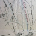
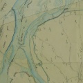
: Plan géométral des Brotteaux de la communauté de Miribel. English title: Geometrical plan of the Brotteaux in the community of Miribel.")
Original title (in French): Plan géométral des Brotteaux de la communauté de Miribel. English title: Geometrical plan of the Brotteaux in the community of Miribel.
- Autor
- Mégnier
- Tags
- Fonds/Photographic fund
- Archives Départementales de l'Ain (reference: 100Fi 43, 100Fi 44)
- Contributeurs/Contributors
- Nature de la ressource/Resource type
- Map
- Date
- Période/Period
- 1775
- Commune/Municipality
- Secteur/Sector
- Miribel (8 km long)
- Echelle/Scale
- 200 perches of 22 feet each
- Lieu visé ou point de visée/Targeted place or photographer geolocation
- Projet OHM/OHM project
- Complément d'information/Additional information
- 2 maps
- Ressource liée/Linked resource
- DOI
- Copyright
- Creative Commons (BY-NC)