
184/350
)
)
)
)
)
)
)
: Prolongement de la digue de l'Ile Roi sur 1970 m à l'amont et 710 m à l'aval du Pont-St-Esprit pour l'amélioration du halage dans la traversée du pont et pour la conservation du port de la ville du St Esprit. English title: Extension of the Roi island dyke over 1970 m upstream and 710 m downstream of Pont-St-Esprit to improve towing at the bridge crossing and for the conservation of the St Esprit port.")
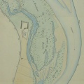
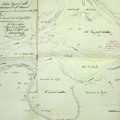
Original title (in French): Prolongement de la digue de l'Ile Roi sur 1970 m à l'amont et 710 m à l'aval du Pont-St-Esprit pour l'amélioration du halage dans la traversée du pont et pour la conservation du port de la ville du St Esprit. English title: Extension of the Roi island dyke over 1970 m upstream and 710 m downstream of Pont-St-Esprit to improve towing at the bridge crossing and for the conservation of the St Esprit port.
- Author
- Ponts & Chaussées
- Tags
- Fonds/Photographic fund
- Archives Départementales du Rhône (reference: S 1423)
- Contributeurs/Contributors
- Nature de la ressource/Resource type
- Map
- Date
- Période/Period
- NA
- Commune/Municipality
- Secteur/Sector
- Pont-St-Esprit (4,5 km long)
- Echelle/Scale
- 1/5000
- Lieu visé ou point de visée/Targeted place or photographer geolocation
- Projet OHM/OHM project
- Complément d'information/Additional information
- Not entirely photographed
- Ressource liée/Linked resource
- DOI
- Copyright
- Creative Commons (BY-NC)
- Make
- Canon
- Model
- Canon PowerShot G9
- DateTimeOriginal
- 2018:12:18 15:16:13
- ApertureFNumber
- f/3.2