
Início / OHM Vallée du Rhône / Archives cartographiques et topographiques /
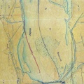
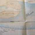
Map (Rochemaure to Donzère, 1843)
161/350
)
)
)
)
)
)
)
: Plan d'une partie du cours du Rhône à l'appui de l'avant-projet des ouvrages à faire sur les deux rives de ce fleuve pour l'amélioration de la navigation (...). English title: Plan of part of the Rhône river in support of the preliminary design of the works to be carried out on both banks of this river to improve navigation (...).")
Original title (in French): Plan d'une partie du cours du Rhône à l'appui de l'avant-projet des ouvrages à faire sur les deux rives de ce fleuve pour l'amélioration de la navigation (...). English title: Plan of part of the Rhône river in support of the preliminary design of the works to be carried out on both banks of this river to improve navigation (...).
- Autor
- Josserand
- Tags
- Fonds/Photographic fund
- Archives Départementales du Rhône (reference: S 1395)
- Contributeurs/Contributors
- Nature de la ressource/Resource type
- Map
- Date
- Période/Period
- 1843
- Commune/Municipality
- Secteur/Sector
- Rochemaure to Donzère (15,5 km long)
- Echelle/Scale
- 1/10 000
- Lieu visé ou point de visée/Targeted place or photographer geolocation
- Projet OHM/OHM project
- Complément d'information/Additional information
- Ressource liée/Linked resource
- DOI
- Copyright
- Creative Commons (BY-NC)
- Make
- Canon
- Model
- Canon PowerShot G9
- DateTimeOriginal
- 2018:12:18 14:35:16
- ApertureFNumber
- f/2.8