
Inicio / OHM Vallée du Rhône / Archives cartographiques et topographiques /
Map/Cross section (Baix, 1848)
216/350
)
)
)
)
)
)
)
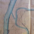
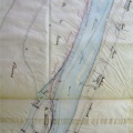
: Nouveau plan général à l'appui du projet des ouvrages à faire pour la construction de deux parties de digues insubmersibles, sur la rive droite du Rhône, immédiatement au-dessus du village de Baix. English title: New general plan in support of the project of the works to be carried out for the construction of two parts of unsubmersible dykes, on the right bank of the Rhône river, immediately above the village of Baix.")
Original title (in French): Nouveau plan général à l'appui du projet des ouvrages à faire pour la construction de deux parties de digues insubmersibles, sur la rive droite du Rhône, immédiatement au-dessus du village de Baix. English title: New general plan in support of the project of the works to be carried out for the construction of two parts of unsubmersible dykes, on the right bank of the Rhône river, immediately above the village of Baix.
- Autor
- Josserand
- Tags
- Fonds/Photographic fund
- Archives Départementales du Rhône (reference: S 1344)
- Contributeurs/Contributors
- Nature de la ressource/Resource type
- Map/Cross section
- Date
- Période/Period
- 1848
- Commune/Municipality
- Secteur/Sector
- Baix (7 km long)
- Echelle/Scale
- 1/2500
- Lieu visé ou point de visée/Targeted place or photographer geolocation
- Projet OHM/OHM project
- Complément d'information/Additional information
- General map and 4 cross sections
- Ressource liée/Linked resource
- DOI
- Copyright
- Creative Commons (BY-NC)
- Make
- Canon
- Model
- Canon PowerShot G9
- DateTimeOriginal
- 2018:12:04 14:26:13
- ApertureFNumber
- f/2.8