
Início / OHM Vallée du Rhône / Archives cartographiques et topographiques /
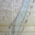
Cross section (Beaucaire, 1844-1847)
57/350
)
)
)
)
)
)
)
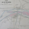
: Profils en long relatifs à l'exécution du port aval de Beaucaire. English title: Long profiles related to the execution of the downstream port of Beaucaire.")
Original title (in French): Profils en long relatifs à l'exécution du port aval de Beaucaire. English title: Long profiles related to the execution of the downstream port of Beaucaire.
- Autor
- Kleitz
- Tags
- Fonds/Photographic fund
- Archives Départementales du Rhône (reference: S 1434)
- Contributeurs/Contributors
- Nature de la ressource/Resource type
- Cross section
- Date
- Période/Period
- 1844-1847
- Commune/Municipality
- Secteur/Sector
- Beaucaire (Ponctual data)
- Echelle/Scale
- 1/2000
- Lieu visé ou point de visée/Targeted place or photographer geolocation
- Projet OHM/OHM project
- Complément d'information/Additional information
- 3 cross sections
- Ressource liée/Linked resource
- DOI
- Copyright
- Creative Commons (BY-NC)