
Inicio / OHM Vallée du Rhône / Archives cartographiques et topographiques /
Map (Villeneuve-lès-Avignon, 1853)
207/350
)
)
)
)
)
)
)
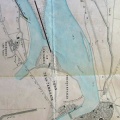
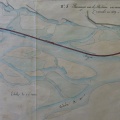
: Plan de la lône de Lamotte après les avaries causées par la crue du mois d'août 1852. English title: Plan of the abandoned channel at Lamotte after the damages caused by the flood of August 1852.")
Original title (in French): Plan de la lône de Lamotte après les avaries causées par la crue du mois d'août 1852. English title: Plan of the abandoned channel at Lamotte after the damages caused by the flood of August 1852.
- Autor
- Aymard
- Tags
- Fonds/Photographic fund
- Archives Départementales du Rhône (reference: S 1435)
- Contributeurs/Contributors
- Nature de la ressource/Resource type
- Map
- Date
- Période/Period
- 1853
- Commune/Municipality
- Secteur/Sector
- Villeneuve-lès-Avignon (0,5 km long)
- Echelle/Scale
- 1/1000
- Lieu visé ou point de visée/Targeted place or photographer geolocation
- Projet OHM/OHM project
- Complément d'information/Additional information
- Ressource liée/Linked resource
- DOI
- Copyright
- Creative Commons (BY-NC)
- Make
- Canon
- Model
- Canon PowerShot G9
- DateTimeOriginal
- 2018:12:04 14:51:11
- ApertureFNumber
- f/2.8