
Inicio / OHM Vallée du Rhône / Archives cartographiques et topographiques /
Cross section (Pont-St-Esprit, 1842)
283/350
)
)
)
)
)
)
)
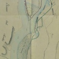
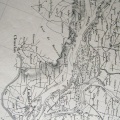
: Profils en long d'après le projet et d'après l'exécution des travaux des digues d'encaissement du Pont-St-Esprit. English title: Long profiles according to the project and according to the work carried out on the Pont-St-Esprit embankment dykes.")
Original title (in French): Profils en long d'après le projet et d'après l'exécution des travaux des digues d'encaissement du Pont-St-Esprit. English title: Long profiles according to the project and according to the work carried out on the Pont-St-Esprit embankment dykes.
- Autor
- Bouvier
- Tags
- Fonds/Photographic fund
- Archives Nationales (France) (reference: F/14/6778)
- Contributeurs/Contributors
- Nature de la ressource/Resource type
- Cross section
- Date
- Période/Period
- 1842
- Commune/Municipality
- Secteur/Sector
- Pont-St-Esprit (Ponctual data)
- Echelle/Scale
- NA
- Lieu visé ou point de visée/Targeted place or photographer geolocation
- Projet OHM/OHM project
- Complément d'information/Additional information
- 3 cross sections
- Ressource liée/Linked resource
- DOI
- Copyright
- Creative Commons (BY-NC)