
Início / OHM Vallée du Rhône / Archives cartographiques et topographiques /
Map (Bourg-St-Andéol to Pont-St-Esprit, 1856)
70/350
)
)
)
)
)
)
)
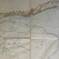
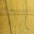
: Inondation du mois de mai 1856. Avaries des digues insubmersibles. Digue de Frémigière et chaussées de l'Union. English title: Flood of May 1856. Damage to unsubmersible dykes. Frémigière dyke and Union roadways.")
Original title (in French): Inondation du mois de mai 1856. Avaries des digues insubmersibles. Digue de Frémigière et chaussées de l'Union. English title: Flood of May 1856. Damage to unsubmersible dykes. Frémigière dyke and Union roadways.
- Autor
- Ponts & Chaussées
- Tags
- Fonds/Photographic fund
- Archives Départementales du Rhône (reference: S 1397)
- Contributeurs/Contributors
- Nature de la ressource/Resource type
- Map
- Date
- Période/Period
- 1856
- Commune/Municipality
- Secteur/Sector
- Bourg-St-Andéol to Pont-St-Esprit (15 km long)
- Echelle/Scale
- 1/10 000
- Lieu visé ou point de visée/Targeted place or photographer geolocation
- Projet OHM/OHM project
- Complément d'information/Additional information
- 2 maps
- Ressource liée/Linked resource
- DOI
- Copyright
- Creative Commons (BY-NC)
- Make
- Canon
- Model
- Canon PowerShot S110
- DateTimeOriginal
- 2020:01:24 16:32:23
- ApertureFNumber
- f/2.0