
345/1165
)
)
)
)
)
)
)
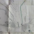
: Construction d'un barrage de 300,70 m de longueur en tête de la lône de St Romain en Gall. English title: Construction of a 300.70 m long dam at the head of the St-Romain-en-Gall abandoned channel.")
Original title (in French): Construction d'un barrage de 300,70 m de longueur en tête de la lône de St Romain en Gall. English title: Construction of a 300.70 m long dam at the head of the St-Romain-en-Gall abandoned channel.
- Auteur
- Kleitz
- Tags
- Fonds/Photographic fund
- Archives Départementales du Rhône (reference: S 1363)
- Contributeurs/Contributors
- Nature de la ressource/Resource type
- Map
- Date
- Période/Period
- 1854
- Commune/Municipality
- Secteur/Sector
- St-Romain-en-Gal (3,5 km long)
- Echelle/Scale
- 1/10 000
- Lieu visé ou point de visée/Targeted place or photographer geolocation
- Projet OHM/OHM project
- Complément d'information/Additional information
- General and detailed map
- Ressource liée/Linked resource
- DOI
- Copyright
- Creative Commons (BY-NC)