
192/1165
)
)
)
)
)
)
)
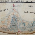
: Plan du cours du Rhône au dessus et au dessous du Port de Roquemaure. English title: Map of the Rhône river above and below the Roquemaure port.")
Original title (in French): Plan du cours du Rhône au dessus et au dessous du Port de Roquemaure. English title: Map of the Rhône river above and below the Roquemaure port.
- Author
- Grangent
- Tags
- Fonds/Photographic fund
- Archives Départementales du Gard (reference: 3S45)
- Contributeurs/Contributors
- Nature de la ressource/Resource type
- Map
- Date
- Période/Period
- 1806
- Commune/Municipality
- Secteur/Sector
- Port of Roquemaure (4 km long)
- Echelle/Scale
- 1/5000
- Lieu visé ou point de visée/Targeted place or photographer geolocation
- Projet OHM/OHM project
- Complément d'information/Additional information
- 3 maps
- Ressource liée/Linked resource
- DOI
- Copyright
- Creative Commons (BY-NC)
- Make
- Canon
- Model
- Canon PowerShot G9
- DateTimeOriginal
- 2017:04:27 04:12:37
- ApertureFNumber
- f/3.2