
20/1165
)
)
)
)
)
)
)
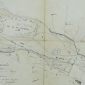
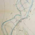
: Plan d'une partie du cours du Rhône à l'effet d'obtenir la construction d'une digue contre ce fleuve dans le territoire de la commune de Viviers. English title: Plan of part of the Rhône river to obtain the construction of a dyke at Viviers.")
Original title (in French): Plan d'une partie du cours du Rhône à l'effet d'obtenir la construction d'une digue contre ce fleuve dans le territoire de la commune de Viviers. English title: Plan of part of the Rhône river to obtain the construction of a dyke at Viviers.
- Autor
- Josserand
- Tags
- Fonds/Photographic fund
- Archives Nationales (France) (reference: F/14/6516)
- Contributeurs/Contributors
- Nature de la ressource/Resource type
- Map
- Date
- Période/Period
- 1843
- Commune/Municipality
- Secteur/Sector
- Viviers (7 km long)
- Echelle/Scale
- 1/10 000
- Lieu visé ou point de visée/Targeted place or photographer geolocation
- Projet OHM/OHM project
- Complément d'information/Additional information
- Ressource liée/Linked resource
- DOI
- Copyright
- Creative Commons (BY-NC)
- Make
- Canon
- Model
- Canon PowerShot G9
- DateTimeOriginal
- 2017:04:24 06:08:48
- ApertureFNumber
- f/2.8