
Accueil / OHM Vallée du Rhône / Archives cartographiques et topographiques /
Map/Cross section (Cruas, 1847)
248/350
)
)
)
)
)
)
)
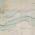
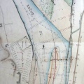
: Plan indiquant la circonscription périmétrale des propriétés intéressées à la construction de la digue de Cruas. English title: Plan showing the perimeters of the properties interested in the construction of the Cruas dyke.")
Original title (in French): Plan indiquant la circonscription périmétrale des propriétés intéressées à la construction de la digue de Cruas. English title: Plan showing the perimeters of the properties interested in the construction of the Cruas dyke.
- Auteur
- Josserand
- Tags
- Fonds/Photographic fund
- Archives Nationales (France) (reference: F/14/6516)
- Contributeurs/Contributors
- Nature de la ressource/Resource type
- Map/Cross section
- Date
- Période/Period
- 1847
- Commune/Municipality
- Secteur/Sector
- Cruas (6 km long)
- Echelle/Scale
- 1/10 000
- Lieu visé ou point de visée/Targeted place or photographer geolocation
- Projet OHM/OHM project
- Complément d'information/Additional information
- Ressource liée/Linked resource
- DOI
- Copyright
- Creative Commons (BY-NC)
- Make
- Canon
- Model
- Canon PowerShot G9
- DateTimeOriginal
- 2017:04:24 06:47:16
- ApertureFNumber
- f/2.8