
736/1165
)
)
)
)
)
)
)
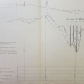
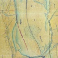
: Projet des travaux à exécuter pour l'endiguement du Rhône sur le territoire de l'Ile de St Romain. English title: Project for the works to be carried out for the embankment of the Rhône river on the St Romain island.")
Original title (in French): Projet des travaux à exécuter pour l'endiguement du Rhône sur le territoire de l'Ile de St Romain. English title: Project for the works to be carried out for the embankment of the Rhône river on the St Romain island.
- Autor
- Josserand
- Tags
- Fonds/Photographic fund
- Archives Nationales (France) (reference: F/14/6706)
- Contributeurs/Contributors
- Nature de la ressource/Resource type
- Map
- Date
- Période/Period
- 1846
- Commune/Municipality
- Secteur/Sector
- St-Romain-en-Gal (0,5 km long)
- Echelle/Scale
- 1/2500
- Lieu visé ou point de visée/Targeted place or photographer geolocation
- Projet OHM/OHM project
- Complément d'information/Additional information
- Ressource liée/Linked resource
- DOI
- Copyright
- Creative Commons (BY-NC)