
Inicio / OHM Vallée du Rhône / Archives cartographiques et topographiques /
Map (St Montant, 1846-1851)
210/350
)
)
)
)
)
)
)
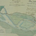
: Plan comparatif des berges du Rhône dans le territoire de St Montant en 1846, 1849 et 1851. English title: Comparative plan of the Rhône river banks at St Montant in 1846, 1849, and 1851.")
Original title (in French): Plan comparatif des berges du Rhône dans le territoire de St Montant en 1846, 1849 et 1851. English title: Comparative plan of the Rhône river banks at St Montant in 1846, 1849, and 1851.

- Autor
- Goux
- Tags
- Fonds/Photographic fund
- Archives Nationales (France), Archives Départementales du Rhône (reference: F/14/6569, S 1409)
- Contributeurs/Contributors
- Nature de la ressource/Resource type
- Map
- Date
- Période/Period
- 1846-1851
- Commune/Municipality
- Secteur/Sector
- St Montant (6 km long)
- Echelle/Scale
- 1/5000
- Lieu visé ou point de visée/Targeted place or photographer geolocation
- Projet OHM/OHM project
- Complément d'information/Additional information
- Ressource liée/Linked resource
- DOI
- Copyright
- Creative Commons (BY-NC)
- Make
- Canon
- Model
- Canon PowerShot G9
- DateTimeOriginal
- 2017:12:08 12:42:24
- ApertureFNumber
- f/4.0